Big Sur
80%
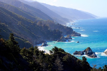
Considered the longest and most scenic stretch of undeveloped coastline in the contiguous United States, this beautiful stretch of California coastline has much to do and see.
Basic Info
Add / Edit
Category
Coastal Region
Price / Entry Fee
FREE
Airport(s) & Port Harbor(s) Service
Monterey Airport (MRY)
San Jose International Airport (SJC)
San Francisco International Airport (SFO)
Oakland Airport (OAK)
Known For
Scenic Views
Top Travel Destination in North America
Day Trip from Major Cities
30 min drive to Point Lobos State Natural Reserve
45 min drive from Carmel (Carmel-by-the-Sea) or Monterey (CA) or Pebble Beach Resorts
2.5 hour drive from San Luis Obispo or San Jose (City) or San Francisco
3 hour drive from Fresno
Winding and/or Bumpy Road (to & around here)
Winding Road: Moderate - Heavy
Altitude/Motion Sickness (to & around here)
Mild - Moderate
Location
See on Google Map
Big Sur, California
Location Boundaries
Region between Carmel Highlands and San Simeon (87 Miles on the Pacific Coast Highway)
Special Info & Comments
South of Monterey Peninsula
The California State Route 1 (Pacific Coast Highway) runs through this region
Loading...
Loading...